


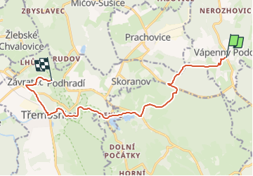

13.9 km | 17.9 km-effort
![Trail On foot Vápenný Podol - [Z] Vápenný Podol - Lovětínská rokle - Photo](https://media.geolcdn.com/t/1900/400/ed4a2dcc-90b9-41d4-a6f1-952f7b0de326.jpeg&format=pjpeg&maxdim=2)

Tous les sentiers balisés d’Europe GUIDE+


FREE GPS app for hiking
 SityTrail
IGN / Geographical institutes
SityTrail World
The world is yours!
Trail On foot of 11.5 km to be discovered at Northeast, Pardubický kraj, Vápenný Podol. This trail is proposed by SityTrail - itinéraires balisés pédestres.
Trail created by cz:KČT.
![Trail On foot Vápenný Podol - [Z] Vápenný Podol - Lovětínská rokle - Photo 1](https://media.geolcdn.com/t/2048/auto/e3ab5e9a-abaa-4f81-9638-f5a33bc824ef.jpeg&format=jpg&maxdim=0 "Trail On foot Vápenný Podol - [Z] Vápenný Podol - Lovětínská rokle - Photo 1")
![Trail On foot Vápenný Podol - [Z] Vápenný Podol - Lovětínská rokle - Photo 2](https://media.geolcdn.com/t/2048/auto/02d6f7e4-7640-4f5a-83fa-ff70ba9edd90.jpeg&format=jpg&maxdim=0 "Trail On foot Vápenný Podol - [Z] Vápenný Podol - Lovětínská rokle - Photo 2")
![Trail On foot Vápenný Podol - [Z] Vápenný Podol - Lovětínská rokle - Photo 3](https://media.geolcdn.com/t/2048/auto/3caf2f57-a0e0-403c-b219-2f66eef05919.jpeg&format=jpg&maxdim=0 "Trail On foot Vápenný Podol - [Z] Vápenný Podol - Lovětínská rokle - Photo 3")
![Trail On foot Vápenný Podol - [Z] Vápenný Podol - Lovětínská rokle - Photo 4](https://media.geolcdn.com/t/2048/auto/d5ee3657-8a19-41bb-95a4-fd4b38768613.jpeg&format=jpg&maxdim=0 "Trail On foot Vápenný Podol - [Z] Vápenný Podol - Lovětínská rokle - Photo 4")
![Trail On foot Vápenný Podol - [Z] Vápenný Podol - Lovětínská rokle - Photo 5](https://media.geolcdn.com/t/2048/auto/2011de84-4439-4056-84ac-37449625bffc.jpeg&format=jpg&maxdim=0 "Trail On foot Vápenný Podol - [Z] Vápenný Podol - Lovětínská rokle - Photo 5")
![Trail On foot Vápenný Podol - [Z] Vápenný Podol - Lovětínská rokle - Photo 6](https://media.geolcdn.com/t/2048/auto/dc42c838-0b8a-4756-886e-b558786d74ff.jpeg&format=jpg&maxdim=0 "Trail On foot Vápenný Podol - [Z] Vápenný Podol - Lovětínská rokle - Photo 6")
![Trail On foot Vápenný Podol - [Z] Vápenný Podol - Lovětínská rokle - Photo 7](https://media.geolcdn.com/t/2048/auto/0de88405-cf49-47df-aff6-b3bba7a52778.jpeg&format=jpg&maxdim=0 "Trail On foot Vápenný Podol - [Z] Vápenný Podol - Lovětínská rokle - Photo 7")
![Trail On foot Vápenný Podol - [Z] Vápenný Podol - Lovětínská rokle - Photo 8](https://media.geolcdn.com/t/2048/auto/dd0e2264-0105-45bd-a15c-a3f03e090165.jpeg&format=jpg&maxdim=0 "Trail On foot Vápenný Podol - [Z] Vápenný Podol - Lovětínská rokle - Photo 8")
![Trail On foot Vápenný Podol - [Z] Vápenný Podol - Lovětínská rokle - Photo 9](https://media.geolcdn.com/t/2048/auto/ed4a2dcc-90b9-41d4-a6f1-952f7b0de326.jpeg&format=jpg&maxdim=0 "Trail On foot Vápenný Podol - [Z] Vápenný Podol - Lovětínská rokle - Photo 9")
![Trail On foot Vápenný Podol - [Z] Vápenný Podol - Lovětínská rokle - Photo 10](https://media.geolcdn.com/t/2048/auto/5a819093-89f3-4247-91c4-97d11a0bb6a3.jpeg&format=jpg&maxdim=0 "Trail On foot Vápenný Podol - [Z] Vápenný Podol - Lovětínská rokle - Photo 10")
![Trail On foot Semtěš - [Ž] Konopáč - Semtěš - Photo](https://media.geolcdn.com/t/375/260/4b4cb51a-3f87-4840-8d60-7e3ab3cd869f.jpeg&format=jpg&maxdim=2)
On foot
On foot
![Trail On foot České Lhotice - [Z] Libáň - Křižanovická přehrada - Photo](https://media.geolcdn.com/t/375/260/2ce85a53-5231-488f-9215-22bd0c81978f.jpeg&format=jpg&maxdim=2)
On foot
![Trail On foot Čáslav - [Z] Čáslav - Pod Tisou skálou - Photo](https://media.geolcdn.com/t/375/260/946bc21c-d4b8-4dc3-b551-c6568a399953.jpeg&format=jpg&maxdim=2)
On foot
![Trail On foot Rabštejnská Lhota - [Ž] Chrudim - Podhůra - Rabštejnská Lhota - Photo](https://media.geolcdn.com/t/375/260/a13872a9-b837-4337-b291-a43ad8f7a8bb.jpeg&format=jpg&maxdim=2)
On foot
![Trail On foot Běstvina - [Z] Běstvina - Seč - Photo](https://media.geolcdn.com/t/375/260/1fe36d45-751d-4c3f-8910-968f469449fc.jpeg&format=jpg&maxdim=2)
On foot
![Trail On foot Zdechovice - [Ž] Morašice - Svojšice - Photo](https://media.geolcdn.com/t/375/260/f143d729-598a-40d2-b273-3cfaab803058.jpeg&format=jpg&maxdim=2)
On foot
![Trail On foot Valy - [Č] Heřmanův Městec - Lepějovice - Photo](https://media.geolcdn.com/t/375/260/54f32eee-5fd1-4854-b492-42524c595dd4.jpeg&format=jpg&maxdim=2)
On foot
![Trail On foot Kladruby nad Labem - [Č] Kladruby - Přelouč - Photo](https://media.geolcdn.com/t/375/260/f96fe7b0-7312-4d06-9975-7d9efd906da9.jpeg&format=jpg&maxdim=2)
On foot